

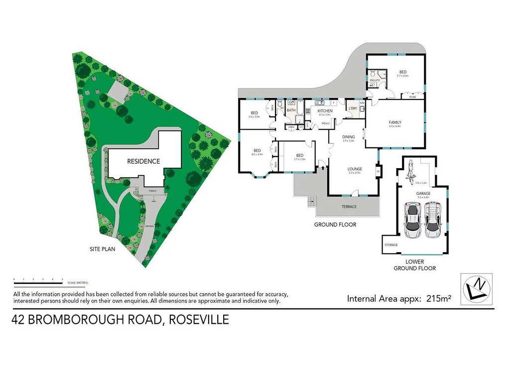
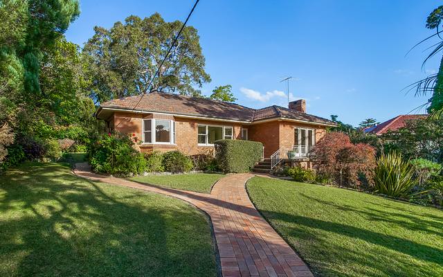
house 4 2 2
Distance To CBD: 10.2 km
Land Size: 1195 m2
Agency: Stone Real Estate - Lindfield
$2,200,000 - $2,899,000Total
$ 132,654
Mortgage registration fee $105
Transfer fee $209
Stamp duty on property $132,340
Monthly Repayment
$ 11,467
Total interest payable $1,991,944
Loan Term 30 years
Annual Interest Rate 5.00%
| Address | Type | Sold Price | ||
|---|---|---|---|---|
| 10 Malvern Avenue Roseville 2069 | house | 4 | Mar 2024 | $3,532,000 |
| 2A Earl Street Roseville 2069 | house | 4 | Mar 2024 | $3,200,000 |
| 16 Spearman Street Roseville 2069 | house | 4 | Feb 2024 | $4,275,000 |
| 110 Shirley Road Roseville 2069 | house | 4 | Dec 2023 | $3,138,000 |
| 80 Shirley Road Roseville 2069 | house | 4 | Dec 2023 | $3,900,000 |
| 17 Barcoo Street Roseville 2069 | house | 4 | Dec 2023 | $3,210,000 |
| 4 Archbold Road Roseville 2069 | house | 4 | Dec 2023 | $2,900,000 |
| 13 Glen Road Roseville 2069 | house | 4 | Nov 2023 | $3,450,000 |
| Address | Type | Rent Price | ||
|---|---|---|---|---|
| 16 Boundary Street Roseville 2069 | house | 4 | Mar 2024 | $1,275 p/w |
| 26 Carnarvon Road Roseville 2069 | house | 4 | Mar 2024 | $1,400 p/w |
| 4 Archbold Road Roseville 2069 | house | 4 | Feb 2024 | $1,200 p/w |
| 23 Margarate Street Roseville 2069 | house | 4 | Feb 2024 | $1,280 p/w |
| 16 Boundary Road Roseville 2069 | house | 4 | Feb 2024 | $1,500 p/w |
| 157 Archer Street Roseville 2069 | house | 4 | Jan 2024 | $970 p/w |
| 36A William Street Roseville 2069 | house | 4 | Jan 2024 | $2,500 p/w |
| 4 Valley View Close Roseville 2069 | house | 4 | Jan 2024 | $1,700 p/w |
| Address | Price | Result* | |
|---|---|---|---|
| 396 Eastern Valley Wy | N/A | W | 3 |
| 18 Ferncourt Av | $3,820,000 | S | 4 |
| 22 Glen Rd | N/A | SP | 5 |
| 48 Carnarvon Rd | N/A | SP | 3 |
| Address | Price | Result* | |
|---|---|---|---|
| 41/15-17 Corona Av | N/A | PI | 2 |
| 425 Penshurst St | N/A | W | 5 |
| 2 Spearman St | N/A | SP | 5 |
| 25 Duntroon Av | N/A | S | 4 |
| 68 Lord St | N/A | SP | 5 |
| 15 Abingdon Rd | N/A | SP | 3 |
| 39/17-25 Boundary St | N/A | PI | 2 |
| 23/5-17 Pacific Hwy | N/A | SP | 1 |
| 22 Longford St | N/A | SP | 5 |
| 310/989-1015 Pacific Hwy | N/A | W | 4 |
| 2A Earl St | $3,200,000 | SP | 4 |
| 8/12 Nola Rd | N/A | W | 3 |
10.27 km to CBD)$3,800,000
$990,000

 Roseville College Chatswood High School
  Chatswood Public School Holy Family Catholic Primary School St Pius X College Lindfield Montessori Preschool Mercy Catholic College Our Lady of Dolours Catholic Primary School Masada College Roseville Public School